 Geography
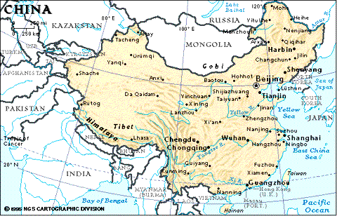
Modern day China is located between the Pacific Ocean and the Plains of Pamir (now in Tajikistan). Like any ancient empire, it began with small tribes roaming around small areas, and China was the result of continuous expansion and amalgamation. Modern day China has an area of some nine million sq km, extending from 71 degrees east to 135 degrees east longitude, and from 4 degrees (this is debatable, since it includes the Spratly's) north to 53 degrees north latitude. It borders the East China Sea, Korea Bay, Yellow Sea, and South China Sea, and is between North Korea and Vietnam.
China's terrain composes of mostly mountains, high plateaus, deserts in west, and plains, deltas, and hills in east. The lowest point of the country is in Turpan Basin, at -154m, while the highest point is on Mount Everest, at 8,848m.
All accounts agree that the basin of Huang He (the Yellow River) was the cradle of the Chinese race, and that our ancestors were a nomadic people who, some five or six thousand years ago, migrated from the north-western part of Asia and finally settled in the northern-central part of what is now China.
Cities
The 1996 estimate of China's population stands at about 1,210 millions, of which 26% are 14 years old and below, 67% are between 15 to 64 years old, and 7% are 65 years old and above. The population growth rate is estimated to be 0.98%, with a birth rate of 17.01 per 1,000 population and a death rate of 6.92 per 1,000 population. The net migration rate is estimated to be -0.34 migrant(s) per 1,000 population. The sex ratio is estimated at 1.11 males to female at birth, 1.1 males to female at for those 15 years old, 1.07 males to female for those between 15 and 64 years old, and 0.86 male to female for those 65 years old and over. The overall sex ratio is estimated at 1.06 male(s) to female. Infant mortality rate is estimated at 39.6 deaths per 1,000 live births, while life expectancy at birth is estimated at 69.62 years for the total population, 68.33 years for male, and 71.06 years for female. The total fertility rate is about 1.81 children born per woman.
Han Chinese makes up for 91.9% of the total population, while Zhuang, Uygur, Hui, Yi, Tibetan, Miao, Manchu, Mongol, Buyi, Korean, and other ethnic groups make for the remaining 8.1%.
The number of dialects listed for China is 206. Of those, 205 are living dialect and 1 is extinct. Of these, the most common are Mandarin (Putonghua, based on the Beijing dialect), Yue (Cantonese), Wu (Shanghaiese), Minbei (Fuzhou), Minnan (Hokkien-Taiwanese), Xiang, Gan, and Hakka .
Literacy for those 15 years old and over who can read and write is estimated at 81.5% for the total population, with 89.9% for male and 72.7% for female.
The current government is secular in nature, but traditional Chinese religions such as Buddhism and Taoism, as well as there is a large number of Christians (est. 1%) and Muslim (est. 2-3%) as well.
For administrative purpose, the country is divided into 23 provinces (Anhui, Fujian, Gansu, Guangdong, Gizhou, Hainan, Hebei, Heilongjiang, Henan, Hubei, Hunan, Jiangsu, Jiangxi, Jilin, Liaoning, Qinghai, Shaanxi, Shandong, Shanxi, Sichuan, Yunnan, and Zhejiang), 5 autonomous regions (Guangxi, Nei Mongol (Inner Mongolia), Ningxia, Xinjiang, and Xizang (Tibet)), and 3 municipalities (Beijing, Shanghai, and Tianjin). Note that China considers Taiwan its 23rd province.
Natural resources include coal, iron ore, petroleum, mercury, tin, tungsten, antimony, manganese, molybdenum, vanadium, magnetite, aluminum, lead, zinc, uranium, and hydropower potential (world's largest.)
Of the total land area of 9,326,410 sq km, about 10% is arable land, 31% is meadows and pastures, 14% is forest and woodland, and 45% of various other types of geography. There is an estimated 478,220 sq km of irrigated land in China in 1991.
The vast area of China is usually divided into nine areas. The names of these areas have no administrative purpose (except maybe for the military), but merely refers to certain geographic area within the country.
He Xi (West of the River) Corridor - a some 1,100 km long area running southeast between eastern end of Tian Shan mountain range and Lanzhou, flanked on the north by deserts and the south by the Qi Lian Mountain Range. The only route for old China to reach the kingdoms on its western fringes.
Xi (Western) Area - the triangular area between the Altai Mountain Range, the Tian Mountain Range, and the Kun Lun Mountain Range, including the Zhun Ge Er Basin and Ta Li Mu Basin. Mostly areas of the Xinjiang Province.
He Tu (The River Cover) - northern half of the area encompassed by the bend in Huang He, including the Ordos Plateau and Ordos Desert. A poor area in terms of resources, but made rich by a good irrigation system for the area between Huang He and Yin Mountain Range.
Sai Bei (North of the Fortresses) - also referred to as Mo Nan (Southern part of the Deserts.) The area between the Great Wall and southern boundary of Mongolia, in Inner Mongolia. 95% of old China's foreign conflicts originate from this area. The fortresses refer to the Great Wall, and the Deserts refer to the Han Hai Desert Group.
Mo Bei (Northern part of the Deserts) - the area north of Sai Bei, from Mongolia to Lake Baykal. Usually the homes of old China's northern invaders.
Dong Bei (the Northeast) - also referred to as Liao Dong (Eastern part of Liao) or Manchuria. Area north of the eastern end of the Great Wall, the San Hai Guan (Gate.) Coldest area in China. Consisting of the Hei Long Jiang and Song Hua Jiang, as well as the rich Hei Long Jiang Plain and Song Hua Jiang Plain, this area can become an economic and military unit independent from China.
Yun Gui Plateau - the area of Yunnan and Guizhou Provinces, consisting of numerous tall mountains, fast rivers, and deep valleys. Mostly separated from old China because the mountains.
Qing Zang Plateau - the plateau of Tibet, the "Roof of the World."
China - China proper in the old days. Further divided into seven smaller areas:
Zhong Yuan (the Plains in the Middle) - the plains of northern China. Delimted in the east by the coast to East China Sea, the south by Huai He (River), the west by Han Gu Guan (Gate) (one of the Great Wall's gate towers,) and the north by the Great Wall. Also referred to as Guan Dong (East of the Gate, referring to Han Gu Gate.) The Han race originated and developed in this area, and the area played a pivotal role in Chinese history.
He Dong (East of the River) - area between Huang He and Tai Hang Mountain Range. Also referred to as Shan Xi (West of the Mountains.)
Guan Zhong (inside the Gates) - area north of Qin Mountain Range and south of the Great Wall. Named so because Xian, the old capital, was located inside the Gates of the Great Wall.
Long Xi (West of the Long Mountain) - areas of eastern Gansu Province and southern Ningxia Province, between He Xi Corridor and Guan Zhong, with Long Mountain to the east and Lanzhou to the west. Part of the Huang Tu (Yellow Earth) Plateau along with Guan Zhong and He Dong.
Jiang Huai - small, narrow area of plains between Chang Jiang and Huai He (River.)
Ba Shu - the 200,000 sq. m. area of Sichuan Basin in Sichuan Province. Ba is another name for the city of Chongqing, while Shu is for the city of Chengdu. Only link to the east is via the difficult to voyage Three Gorges of Chang Jiang. Once river works on the Three Gorges was completed in the third century B.C., the area grew in wealth, and, because of its geography, had the potential to, and often did, become independent from old China in terms of its economy and military power. Many kingdoms and empires were launched from here.
Jiang Nan (South of the River) - also referred to as Hua Nan (southern Hua or southern China.) Area south of Chang Jiang and north of Vietnam. It was gradually developed as the Han race was forced to migrate south over the centuries due to warfare in the north.
Hei Long Jiang (Black Dragon River, a.k.a. Amur River) - the northern most watercourse in China, forming part of the border with Russia. 2,965 km of its 4,485 km flows within China.
Huang He (Yellow River) - 5,464 km long, second longest river in China. Named after the yellow sediments it carries from the Huang Tu (Yellow Earth) Plateau in the west. The most important river in Chinese history, as it changed course and flooded some 1,500 times within the 4,000 years between twenty-third century B.C. and the beginning of twentieth century A.D., killing numerous people and livestock every time.
Chang Jiang (Long River) - Longest river in China, 6,300 km in length. Contrary to Huang He, it was more beneficial than harmful to the people. Splits China in half, thus the area north of Chang Jiang are is often referred to as Northern China, and the area south as Southern China.
Zhu Jiang (Pearl River) - Only 80 km long itself, but it has three main branches of Xi Jiang (West River), Dong Jiang (East River), and Bei Jiang (North River), with the 2,129 km long Xi Jiang as the main branch. It only came into prominence after the Opium War in the nineteenth century.
Qing Hai (the Cyan Sea) - the largest salt water lake in China, located to the west of Lanzhou with an area of 4,427 sq. km.
Dong Ting Hu (Dong Ting Lake) - located north of Changsha, with an approximate area of 3,915 sq. km. Serves as a flow regulator for Chang Jiang, and can increase to up to 5,000 sq. km when the Chang Jiang rises. The provinces Hunan (South of the Lake) and Hubei (North of the Lake) refer to this lake.
Tai Hu (Tai Lake) - a lake of 2,213 sq. km located west of Shanghai, in the delta on the lower reaches of Chang Jiang. Areas around this lake are rich in agriculture and fisheries, with the richest farmers and fishermen in China, thus gaining the name "the Land of Fishes and Rice."
Tai Hang Shan - the first mountain range to play a part in Chinese history. Runs from the northwest of Beijing to the north shore of Huang He. East of this range, the Hebei Plains average 20 metres above sea level, while west of the range, the Shanxi (West of the Mountains) Plateau, forming part of the Huang Tu (yellow earth) Plateau, averages over 1,000 meters above sea level. The Tai Hang mountain range averages 1500 metres in elevation, running some 800 km in length in a north-southerly direction, with only eight valleys possible for passage. Played a significant role in national defence till the twentieth century.
Qin Lin - runs for some 700 km in an east-westerly direction south of Xian, averaging 2500 metres in elevation. It is the location for the famous and strategically important "mountain routes" project, which entailed digging holes on cliff faces, inserting iron bars into the holes, and putting wooden planks on top to make passages through the mountains.
Qi Lian Shan - runs for some 1,000 km between Tian Shan in Xinjiang Province and Lanzhou, the geographic centre of China. The rich area north of Qi Lian mountain range is called the He Xi (West of the River) corridor.
Yin Shan - runs some 600 km north of the bend in Huang He, in Inner Mongolia. As north side of the mountain is the Gobi Desert, expansion of agriculture stopped on the south side of the mountain.
Kun Lun Shan - runs for 2,500 km to the east from the Pamir Plains, averaging 5,000 to 7,000 metres in elevation. To the north is Ta Li Mu Basin, and, combined with the Himalayas to the south, forms the Roof of the World (the Tibet Plateau.)
The Himalayas - world famous mountain range, averaging 4,500 metres in elevation. It�s tallest peak, Mount Everest, peaks at an elevation of 8,848 metres. It severed India from China, stopped Genghis Khan from crossing west, and stopped the British Empire expanding north from India.
Song Shan - located in Henan Province, 2,000 metres in height, with three peaks. The famous Shaolin Temple is at the foot of one of the peaks.
Tai Shan - located in Shangdong Province, 1,540 metres in height. It�s prominence is due to its being surrounded by plains, and its role in history as the ideal site for emperors� rituals of giving offerings to heaven and earth.
Hua Shan - located in Shaanxi Province, 2,200 metres in height, with three main peaks and many minor peaks.
Heng Shan - located in Shanxi Province, 2,200 metres in height, with one main peak. Many temples are scattered on the mountain.
Heng Shan - no, its not a typo, just the same phonetic translation. This Heng Shan is located in Hunan Province, with a height of only 900 metres. However, its complicated geographic profile consists of 72 major peaks, with numerous temples scattered throughout.
Five deserts of large areas cover 6% of China, concentrating in four areas to the north and west of the Great Wall.
Zhun Ge Er Basin - a triangular area of 380,000 sq. km, including the 50,000 sq. km Gurbantunggut Desert, located in the north of Xinjiang Province between Tian Shan and Altai Shan. It played no part in Chinese history until the eighteenth century, when Manchurian troops of the Qing government "ethnically cleasned out" the Zhun Ge Er people, and killed every last one of them. All that is left of Zhun Ge Er today is a name for the basin and a gateway between China and Russia.
Ta Li Mu Basin - an area 530,000 sq. km located between Tian Shan and Kun Lun Shan. 80% of it is covered by the 330,000 sq. km Takli Makan Desert and the 100,000 Bai Long Dui Desert. The basin is locked in all around by mountains over 4,000 metres high, with contact to the He Xi Corridor to the northeast. The Takli Makan Desert is equivalent to Japan in area, and is of the quick sand type, while Bai Long Dui Desert is equivalent in area to half of England. In the local dialect, "Takli Makan" means "you can enter, but you cannot return."
Ordos Shamo (Ordos Desert) - located on the Ordos Plateau, south of the bend of Huang He (Yellow River). When Yin Shan, on the north side of the bend, was the northern boundary of China, this desert was an obstacle to troop movement and supply lines.
Han Hai (Ocean-like) Desert Group - the most influential desert group on Chinese history. An area of 1,500,000 sq. km, equivalent of four Japans, composing of many individual deserts with barren land in between. Spans some 2,000 km from the south side of Dai Xing An Ling (Dai Xing An Mountain) in the east to the east side of Tian Shan to the west, and between 400 km to 1,000 km from the north of Yin Shan and the Great Wall in the south to the heart of Mongolia in the north. The string of commerce towns on the south side are like ports to an ocean, where caravans must stop and load up before setting off into the desert. Nomads living in the desert group had always wanted to move into the richer land to the south, i.e. China, resulting in 95% of China�s foreign threats coming from the north.
The unceasing invasions spurred the construction of the Great Wall. Since eighth century B.C., individual kingdoms had already building individual walls to defend against northern invaders. In third century B.C., when the Qin kingdom unified China and needed to defend against invaders from a newly unified northern kingdom, all individual walls were connected to become the first complete line of defence.
The Great Wall served China well for over a thousand years, until the Liao Empire successfully invaded into the area to the south of the Great Wall. With the rise of the Jin and Mongol Empires, the Wall was deserted as it was located in the heartland of these empires. It was not until the fifteenth century, when the Ming Dynasty, built by Hans, were able to drive the Mongols back north, that the Great Wall was repaired and once again served its function. However, with the Qing Dynasty, built by Manchurians from the north, took China, as well as Inner and Outer Mongolia, in the seventeenth century, the Great Wall once again lost its defensive value.
Xian, Shaanxi - was a capital for 1,171 years. Located near the Wei River and within the Great Wall�s protection, it was the centre of old China. It lost its ability to be a capital only in the ninth century, when its irrigation system was destroyed by rebel armies and foreign invaders. Home to many historical sites.
Luoyang, Henan - was a capital for 857 years. Built as a twin city 20 km apart in the eleventh century B.C., and soon became the political and cultural centre of old China. It�s strategically critical location made it a target for any civil war, thus the city had been razed time and again, leading to its demise after the tenth century. Home to as many historical sites as Xian.
Beijing, Hebei - was a capital for 779 years. The political centre for China since the twelfth century, once China stepped into the era of unity, and its local dialect was designated the official dialect of China at the beginning of the twentieth century.
Xiayuan, Shanxi - was a capital for 440 years. Built in the twenty-third century B.C..
Nanjing, Jiangsu - was a capital for 429 years. Built in the third century. Since the population of old China was concentrated in northern China, most of its tenure as old China�s capital were only during periods of unrest and breakdown.
Jiangling, Hubei - was a capital for 419 years. Built in the seventh century B.C..
Kaifeng, Henan - was a capital for 350 years. It was the worse location for a capital, as it was open on all sides, allowing any invader to simply walk up to the city.
Shangqiu, Henan - was a capital for 271 years. Built in the eighteenth century B.C..
Hangzhou, Zhejiang - was a capital for 220 years. One of the most beautiful cities of old China. However, more so than Nanjing, its location made it suitable only as a capital during periods of unrest or breakdown.
Xinzheng, Henan - was a capital for 205 years. The very first capital of China, built in the twenty-seventh century B.C..
Anyang, Henan - capital of the twelfth century B.C. Shang Dynasty for 204 years. Site of the oracle bones archaeological discovery in the nineteenth century.
Other mentionables - (most of these cities had been capitals to some kingdom or empire at one time or another throughout history) Lanzhou, Gansu; Guangzhou, Guangdong; Jiangdou, Jiangsu; Wuyuan, Jiangsu; Lhasa, Tibet; Liaoyang, Liaoning; and Dunhuang, Gansu.
 © 1997
This page hosted by  Get your own Free Home Page